
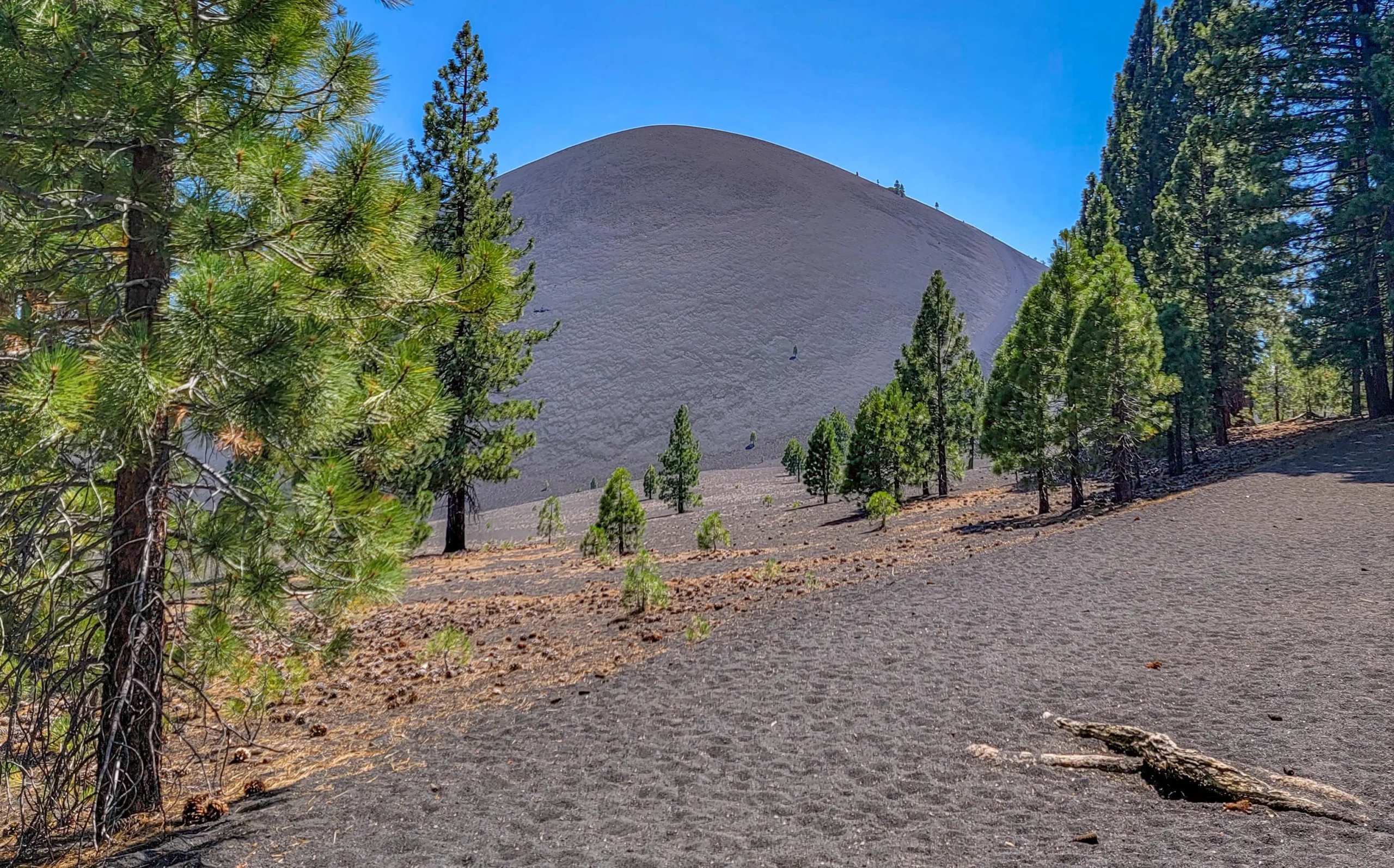

The Cinder Cone Trail is a 4-mile (6.4 km) round trip hike to the summit of a 700-foot (213 m) volcanic cinder cone in the northeast corner of Lassen Volcanic National Park. The trail climbs 846 feet (258 m) from the Butte Lake trailhead at 6,061 feet (1,847 m) to the crater rim at 6,907 feet (2,105 m), and the National Park Service allows about three hours for the round trip.
Cinder Cone erupted in 1666, a date pinned down by tree ring analysis of Jeffrey pines killed and scarred by the eruption. That makes this one of the youngest volcanic landscapes in California, and it looks it — the cone is bare grey cinder, the lava flow beside it is raw black basalt, and the pines are still working their way back across the ash.
This is a short hike with a wildly disproportionate payoff. It’s also harder than four miles and 846 feet suggests, and I want to be straight about why.

Cinder Cone trailhead sign at Butte Lake showing trail distances to Snag Lake, Horseshoe Lake, and Hat Lake
Trail Facts
- Distance: 4 miles (6.4 km) round trip to the summit; 2.4 miles (3.9 km) round trip if you stop at the base
- Elevation change: 846 feet (258 m)
- Elevation range: 6,061 to 6,907 feet (1,847 to 2,105 m)
- Time: About 3 hours round trip
- Difficulty: Moderate, but see the note on cinders below
- Trail surface: Loose volcanic cinder, roughly the consistency of coarse sand
- Season: Approximately June through November
- Trailhead: Butte Lake Day Use Area, near the boat ramp
Getting to the Butte Lake Trailhead
Butte Lake is the most remote developed area in Lassen Volcanic National Park, and getting there is a deliberate act — you can’t reach it from the main park road. Take Highway 44 to the signed turnoff about 24 miles east of the park’s Northwest Entrance, then drive 6 miles (9.7 km) south on a dirt road to the Butte Lake Day Use Area.
That road is the part people underestimate. It’s washboard, gravel, dusty, and slow. Any passenger car can handle it in dry conditions, but plan on at least 20 minutes for those six miles and don’t expect to make up time.
Drinking water is available at the trailhead when Butte Lake Campground is open. There are no other services out here — no store, no gas, no reliable cell signal. Fill up in Old Station or Susanville.
Entrance fee is currently $25 per vehicle for seven days in summer and $10 in winter. Lassen adjusted its fee structure in January 2026, so check the park’s fee page before you go.
Butte Lake Road closes with the first heavy snow, usually in November, and typically reopens in late May or June.
Hiking the Cinder Cone Trail
The trail leaves the Butte Lake parking area and runs south along the edge of the Fantastic Lava Beds, the flow that poured out of Cinder Cone during the eruption. It’s a wall of jagged black basalt standing well above head height in places, and the contrast with the Ponderosa and Jeffrey pines growing right up against it is the first thing that makes this hike feel different from a normal forest walk.

Jagged black basalt of the Fantastic Lava Beds beside the trail
This first stretch is nearly flat and shaded, and it’s deceptive. The cinder underfoot is already soft, and you’re working harder than the grade suggests.
At 1.2 miles (2 km) the trail reaches a fork at the base of the cone. Look south from here for the first view of the Painted Dunes — oxidized volcanic ash in bands of rust, pink, and ochre, colored by the heat of lava flowing over ash that hadn’t yet cooled. There are Jeffrey pines at the fork, and this is the last real shade before the climb. Take it.
The trail also follows a section of the Nobles Emigrant Trail here, one of two routes emigrants used to cross what is now the park. Numbered posts along the way match a free interpretive handout available at the trailhead and park visitor centers.
Climbing the Cinder Cone Trail
The ascent is where this hike earns its reputation. It’s roughly half a mile of switchbacks up the outer slope, and the surface is loose cinder the whole way. You lose a meaningful fraction of every step to backslide. There is no shade, no water, and nothing to grab.

Looking down the loose cinder slope of Cinder Cone toward Butte Lake and the forest below
But, the compensation for the effort starts immediately. Lassen Peak swings into view as the trail curls around toward the south side, and Butte Lake sits below in a bed of black lava. I stopped more on this half mile than on any other part of the hike, and I’d recommend planning to do the same rather than treating it as a failure of fitness.
Trekking poles help here more than on most trails this short. So does starting early — there is genuinely nowhere to hide from the sun on the cone.
The Summit and the Crater
The top is not a peak. It’s a rim trail around a double crater, and the view from it is the reason to do this hike.

Cinder Cone crater rim with the Painted Dunes and surrounding peaks in the distance
From the rim you get views of Prospect Peak, Lassen Peak, Snag Lake, the full sweep of the Fantastic Lava Beds, and the Painted Dunes laid out below in colors that don’t look like they belong in a conifer forest. The rim path circles the whole crater, and the perspective changes enough as you walk it that it’s worth doing the full loop rather than stopping at the first viewpoint.

Interior of the Cinder Cone crater showing the inner cone and steep cinder walls
A second trail drops from the rim into the crater itself. It’s short and steep, and standing inside a volcano that erupted in 1666 is a strange enough experience to be worth the extra climb back out.

Looking down into the inner bowl of the Cinder Cone crater
Descending the Cinder Cone Trail
Going back down the cinder slope is the fun part. The same loose surface that fought you on the way up lets you take long sliding steps on the descent, and it goes much faster than the climb. Gaiters are not a bad idea — you will be emptying cinders out of your boots regardless.

Lone Ponderosa pine growing at the edge of the Fantastic Lava Beds
Know Before You Go
- Cinder Cone pairs well with Subway Cave trail. We hiked Subway Cave in the morning and Cinder Cone the same afternoon, which makes for a great day: a 700-foot cinder cone before lunch, a lava tube after. The only change we might advise is that it is much hotter and unprotected at Cinder Cone, so you might want to think about doing that in the morning so you can do the nice cool lava tube in the afternoon.
- Stay on the trail. Signs at the trailhead ask specifically that hikers avoid tracking the cinder fields, and they mean it — footprints on those slopes persist for years and are visible from the rim. The Painted Dunes are the most fragile surface in the area.
- Dogs are not allowed on this or any trail in Lassen Volcanic. Neither are bicycles.
- Carry more water than you think. Four miles at altitude on an exposed cinder slope in July is a different proposition from four miles of forest trail.
- There is no shade above the fork. Early morning or late afternoon is the way to go in the summer. Afternoon light does good things to the Painted Dunes, but you’ll pay for it on the climb.
- Backcountry permits are required for overnight camping, wood fires are prohibited, and chemical stoves only.
- On fire history: I hiked Cinder Cone in mid-July 2021, a few days after the Dixie Fire started, and we drove past the early edges of it on our way out of the area. At that point it was still a fire in the Feather River Canyon to the south and nobody I talked to expected what came next. It went on to burn a large share of Lassen Volcanic National Park and became the largest single wildfire in California’s recorded history. The Butte Lake corridor came through comparatively well, but the forests you’ll drive through are visibly changed from what’s in these photos, and you’ll see burn scars and prescribed-fire work on the way in. Check current conditions with the park before making the trip.
Is It Worth It?
Four miles is a short hike, and the numbers on the sign make Cinder Cone look like a warm-up. It isn’t — the cinder surface roughly doubles the effort of the climb, and there’s absolutely no shade or water once you leave the fork. Go in expecting a moderate hike rather than an easy one and bring plenty of water, and you’ll enjoy the hike far more.
What you get for your trouble is a summit view that no other trail in Lassen delivers: a crater under your feet, a lava flow and a set of painted ash dunes below, and Lassen Peak on the horizon. Of the short hikes in this park, this is the one I’d do again first.
For more information on things to do in Lassen Volcanic National Park, visit our park guide here.
For current trail conditions, road status, and fees, visit the National Park Service page for Cinder Cone and Lassen Volcanic.

0 Comments